Updated at 10 a.m. ET on Aug. 13, 2025.
Tropical Storm Erin is still struggling to strengthen, but it has a well-developed circulation. Dry and dusty air surrounds the system, and the ocean below is cool. However, conditions are forecast to be much more conducive to strengthening ahead.
The National Hurricane Center is forecasting Erin to slowly strengthen, reaching hurricane strength late tomorrow or early Friday. Though the exact timing when the atmosphere around the system will moisten up, allowing it to spin up, is only an approximation.
Importantly, Erin’s center is forecast to make its closest approach to the northeastern Caribbean islands, including Puerto Rico and the Virgin Islands over the weekend. The consensus of the various computer models and the NHC official forecast predicts the center will be offshore, but effects will be felt on the islands.
BRYAN NORCROSS SHARES HIS JOURNEY INTO METEOROLOGY
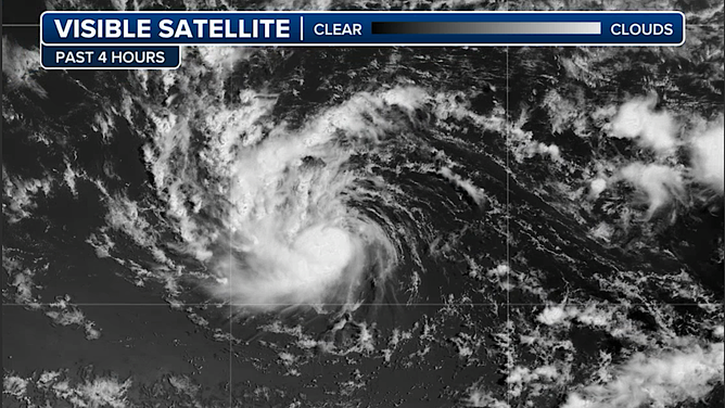
This graphic shows satellite imagery of Tropical Storm Erin.
(FOX Weather / FOX Weather)
Everyone in the northeast Caribbean needs to stay in close touch with the forecasts because a slight deviation to the left of the track would make a significant difference in the wind, rain, and storm surge that impact the islands.
Besides the intrinsic track uncertainty, Erin is forecast to be strengthening as it’s passing north of Puerto Rico, and we know that intensity forecasts are rarely perfect. A stronger storm in close proximity to the islands would change the magnitude of the impact.
Looking into the long range, past when the National Hurricane Center is forecasting and the end of the cone, the consensus is increasing that Erin will turn north before reaching the East Coast of the U.S. The storm looks most likely to pass between the Carolinas and Bermuda, but folks on Bermuda are going to have to watch closely to be sure Erin doesn’t make a hard turn to the north.
In any case, Erin is forecast to be a large, strong hurricane as it heads north offshore of the East Coast. As we have seen too many times, hurricanes with large circulations put a tremendous amount of energy in the water. That energy will reach the mid-Atlantic and northeast coast of the U.S. The current timing looks like the peak effects on the coast will come next Wednesday and Thursday.
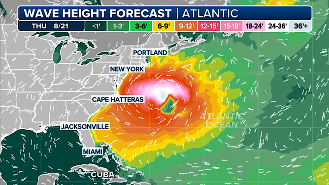
This graphic shows expected wave heights along the East Coast on Thursday, August 21, 2025.
(FOX Weather / FOX Weather)
This is a computer model forecast of wave heights (out in the ocean, not crashing at the coast), but it’s a good representation of the energy the storm will put into the water. The center of Erin could be farther or closer to the coast next Thursday, of course, in which case less or more energy would impact the beaches and waterways.
Large, eroding waves and strong currents, including rip currents, are likely. Caution is going to be required.
Coastal New England and Atlantic Canada will have to monitor the forecasts for possible impacts late next week, just in case Erin takes a low-probability-but-plausible track close to their coasts.
The average error in these long-term forecasts is very large, of course, so we can’t lock onto the details. And we can’t 100% rule out a significant deviation from what we’re expecting based on what we currently know. But for now, we can feel more confident that Erin will not make a direct hit on the continental U.S. Still, we’ll keep an eye on it to be sure.
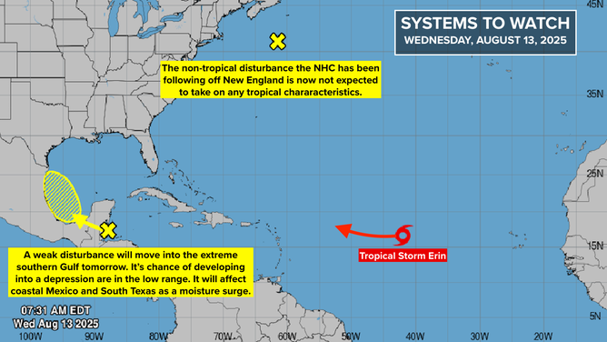
This graphic shows a tropical overview of the Atlantic Basin.
(Bryan Norcross / FOX Weather)
Next in line
Disturbances continue to move off Africa, as we would expect this time of year. Currently, however, none of them looks to be worth tracking in the short term. Though there is a possibility there will be a system of interest moving across the tropical Atlantic next week.
In the Gulf
A weak tropical disturbance in the Western Caribbean will move across Mexico’s Yucatán Peninsula today and into the extreme southern Gulf tomorrow. Conditions there will be somewhat conducive for the system to organize, though it’s not going to have much time.
The National Hurricane Center has the odds in the low category that a tropical depression will form.
Watch for developments along the Mexican Gulf Coast and in South Texas. There is no indication that anything strong would develop, but the southern Gulf is a breeding ground for tropical systems due to the curvature of the coast in the Bay of Campeche. Most likely the main effect will be a surge of tropical moisture.
Off New England
The National Hurricane Center was painting a mini lemon east of Cape Cod, Massachusetts. But now the odds of it briefly taking on some tropical characteristics are down to 0%.


