This week’s storm isn’t finished with Southern California just yet as gusty winds join forces with continuing showers and falling snow Thursday.
“The scattered showers are expected to continue throughout the day today across Southern California before tapering off to nothing this evening,” KTLA’s Kirk Hawkins said. “The majority of shower activity impacts the mountains of L.A., Ventura and of course the Inland Empire.”
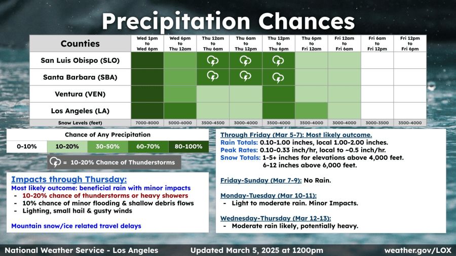
A winter storm warning is in effect for portions of the Riverside and San Bernardino county mountains through 10 a.m. Friday, according to the National Weather Service (NWS).
Snow levels are expected to lower to 3,500 feet or less with 4 to 7 inches of snow possible above the 5,000-foot level. Several inches of snow already fell in the Wrightwood area overnight.
A snow flurry was also captured on video in the Frazier Park area Wednesday night. Additional snow on Thursday could make for difficult driving conditions on the 5 Freeway through the Grapevine area.
“When we talk about the Grapevine, there’s a possibility we could be seeing up to an additional inch of new snow,” Kirk said.
Residents in Southern California’s foothills, especially along the recent burn areas, are keeping an eye out on the hillsides for potential mudslides. The NWS is calling for a 10% chance of minor flooding and shallow debris flows.
Gusty winds will also reach advisory levels around the Southland.
A wind advisory is in place for parts of Los Angeles County through 1 p.m. Thursday. Advisories will remain in place until early Friday morning for some areas further inland.
Residents are expected to get a break this weekend with the arrival of sunny skies and dry conditions but it won’t last long.
Two additional chances of rain arrive next week on Monday and then again Wednesday through Thursday. Wednesday’s storm may be the most significant because it has the potential to tap into an atmospheric river, forecasters said.


