The first in a wave of storms expected to bring significant rainfall to Southern California this week arrived overnight.
“We’re tracking rain as it’s making its arrival to Southern California. The first part of this storm system … just a blob of moisture ahead of the main storm … is moving relatively quickly,” KTLA’s Kirk Hawkins said Wednesday morning.
KTLA’s LIve Radar showed light showers already falling in several areas including Santa Barbara, Long Beach, Oxnard and Westlake Villiage around 4:45 a.m.
Wednesday’s storm is expected to be relatively mild, bringing about a half inch of rain or less to most of the region but it will be followed by a much stronger system on Thursday.
“We’re watching the arrival of a pretty significant storm system that has the potential to be very destructive in some of our burn areas … We could see heavy downpours, significant rainfall rates and a danger of debris flows,” Kirk said.
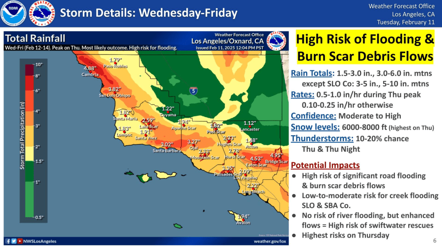
The National Weather Service (NWS) called for a “high risk of flooding and burn scar debris flows” when Thursday’s storm makes its push.
Rain totals in the Los Angeles area are then expected to jump to between 1.5 and 3 inches with up to 6 inches falling in the mountains.

NWS Meteorologist Ariel Cohen described the rain as a “bursting type of pattern” with periods of intense rainfall rates. Peak rain rates could reach a half inch to an inch an hour on Thursday, according to the NWS.
Forecasters are also calling for a 10 to 20% chance of thunderstorms on Thursday with widespread roadway flooding likely.
The timing of the heaviest showers will be between noon Thursday and 6 a.m. Friday, according to the NWS.

Snow levels will start out as low as 6,000 feet on Wednesday with “no more than a dusting” before rising to above 8,000 feet with a slightly warmer system arriving Thursday. “Those resort-level areas could see as much as 20 inches of new snow,” the NWS stated.
Snow levels are likely to drop back to around the 6,000-foot mark in the wake of the storm.
The rain will turn into light showers on Friday before a warming and drying trend begins over the weekend and extends into next week.


