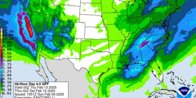
After months of dry weather heading into 2025, Southern California is bracing for its third winter storm event in less than a month, and this week’s system is expected to be the strongest yet.
“Looks like Wednesday, Thursday, Friday we’ll have at least on-again-off-again rain showers. It will accumulate, so we do get some decent rainfall numbers,” KTLA meteorologist Henry DiCarlo said Monday.
A small system will first impact the region on Wednesday, with skies turning cloudy early on and showers arriving in Los Angeles County during the evening hours. This first impulse is expected to bring about a half inch of rain to the L.A. area, according to the National Weather Service.
“Notice on Tuesday we get a little windy. That’s in advance of that cold front,” Henry said.
Most of the rain is expected to fall on Thursday with the arrival of the second system. Rainfall during this period will be light to moderate according to the Weather Service.
“This will be the worrisome portion of the storm as rainfall rates near an inch per hour will be possible just ahead and with the front. People in or near to recent burn areas will
need to by hyper-vigilant of weather conditions during this time frame,” the Weather Service stated.

Forecasters also called for a 10% chance of thunderstorms, capable of producing dangerous rain rates of over one inch per hour as well as gusty winds and possible waterspouts.
An additional one to two inches of rain is expected to fall on the coasts and valleys during this time period with up to four inches possible for the coastal foothills, but NWS noted that several projections indicate more rain could fall in those areas.
Showers are expected to taper off after several early showers on Friday as the system moves out of the region.
The storms are expected to bring a significant amount of snow to our local mountains as well, with levels dropping to around 5,000 feet on Wednesday before rising to near 7,000 feet with Thursday’s warmer front, the Weather Service stated. The snow levels will lower again to around 5,000 feet as the second system moves out of the area.
Elevations above 7,000 or 8,000 feet may see several feet of snow, according to forecasters.
Dry and somewhat warmer conditions are expected to return for the upcoming weekend.


