A pair of storms will bring much-needed rain to Southern California this week but there is concern about the impact on the region’s burn scar areas.
“We’ll start on Tuesday night and then through Wednesday — a pretty wet day for us. We’ll get a little bit of a break on Thursday and then you saw another system kind of sag down on Friday,” KTLA Meteorologist Henry DiCarlo said Monday morning.

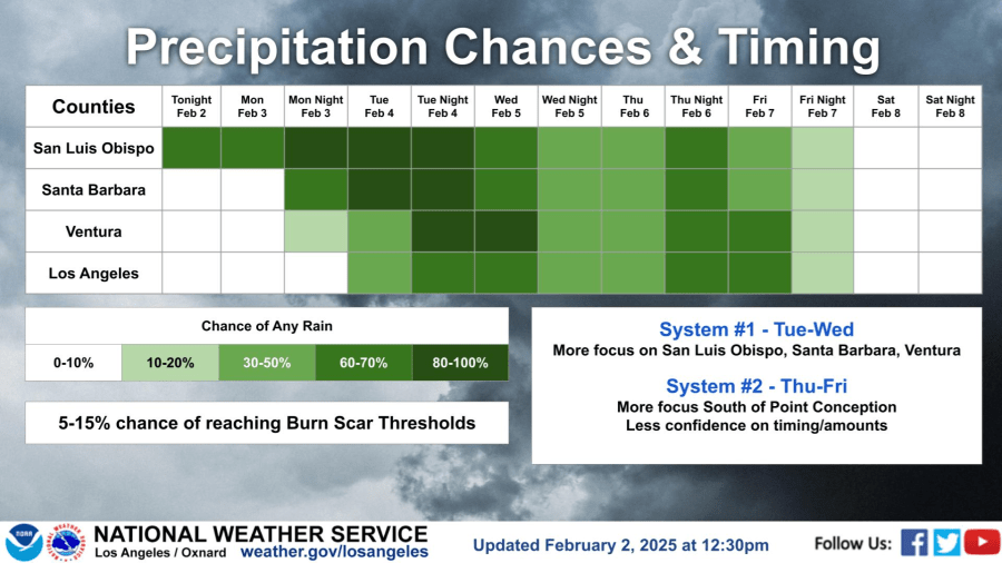
The National Weather Service says the first storm will mostly focus on San Luis Obispo, Santa Barbara and Ventura but the second storm will be directed south of Point Conception.
“Now it comes down to how much rain we’re going to get,” said Henry, who has his eye on an atmospheric river out over the Pacific.
With the first storm mostly hitting to our north, the Weather Service is calling for between a quarter of an inch to an inch of rain in Los Angeles County but just how much the atmospheric river will affect the second storm is still in question.

The Weather Service has “less confidence” in the timing and amounts associated with the storm arriving Thursday into Friday.
Henry said the atmospheric river is pointing to the north so it hopefully won’t have a major impact on the system.
“What will happen on Wednesday, we’ll get the tail end. It kind of dies out but we will get rain … rain that we need we don’t want to see too much of it,” Henry said. “The foothills always squeeze out more … That’s where we get to the increased risk … We have some numbers, if we get to the outlying range of that inch, inch and a half, which is possible in some spots … that can be an issue.”
The Weather Service posted a 5% to 15% chance that the storms would reach the burn scar area thresholds.


