(NEXSTAR) – After months of teasing, a La Niña winter has finally started – but we don’t blame you if you haven’t noticed.
This year’s La Niña is looking short and weak. That makes it less likely we’ll see all the classic effects of a La Niña year, explains Michelle L’Heureux, a meteorologist at the National Weather Service’s Climate Prediction Center, in a recent blog post.
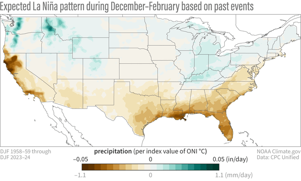
A “typical” La Niña would look like the map below, L’Heureux writes: dry conditions across the southern half of the country, with extra rain and snow up north (especially in the Pacific Northwest and Ohio Valley). But La Niña years aren’t all identical. Some look a lot like the map below, some are pretty close, and others are anomalies.

That’s why La Niña is almost guaranteed to feel like a “bust” somewhere in the country, L’Heureux acknowledges. It would be amazingly rare to see a “perfect” La Niña outcome. There’s way more likely to be some variation than there is to be a 100% match.
Usually, the stronger the La Niña phenomenon is in the equatorial Pacific Ocean, the more likely we are to see the expected weather patterns here on land.
This year’s La Niña isn’t looking particularly strong, which is likely to mean its final impacts look at least a little bit different from the map above.
“In fact, we guarantee a bust somewhere, with busts more likely in regions where the historical ENSO relationships are just not as strong,” L’Heureux writes. The lighter shaded portions of the map are least likely to see characteristic La Niña outcomes. “On the upside, if you can make your bets over multiple winters and over the entire United States (even larger geographic areas tend to improve odds), you’ll still come out ahead more often than not.”
There’s still time left in the winter season, but some southern states have been seeing that classic La Niña dryness. Drought conditions are especially bad in the Southwest, and an exceptionally dry year in Southern California led to dangerous fire conditions. But at the same time, we’ve seen rare snow hit the Southeast and Gulf states.
February’s weather is expected to look a lot more like typical La Niña, according to the Climate Prediction Center.


La Niña isn’t expected to stick around too long. It’s favored to fade away over the spring.


