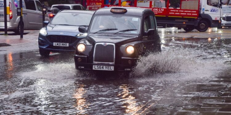
HEAVY rain will drench nearly all of Britain today potentially sparking travel chaos and more flooding.
A Met Office map has revealed the exact time Brits across the UK are set to be hit with torrential downpours.
Fire crews have already been called out to rescue one person in their car this morning after they became trapped in floodwater near Shrewsbury.
By midday a large band of rain will cover most of Britain, with the Midlands and Northern Ireland.
Around 20-40 mm of rain could fall quite widely with a chance that a few places could see 60-80 mm.
Manchester and York are predicted to see the worst of stormy weather this afternoon.
Two yellow weather warnings for rain have been issued across central parts of Britain that last throughout the day.
An alert covering Manchester, Liverpool and Stoke-on-Trent came into force in the early hours of this morning and ends at 8pm.
Meanwhile, the other warning stretches from Hull down to Peterborough, while also encompassing Nottingham and Sheffield.
The notice began from 8am this morning and ends at 3am tomorrow.
The Environment Agency has issued 58 flood warnings where flooding is expects, and 107 alerts where it is possible.
A spokesperson said: “Flooding is possible but not expected from surface water and rivers on Monday and Tuesday in East of England, East Midlands and Yorkshire and the Humber.
“Local flooding is probable from surface water and rivers across much of England from today (Sunday) until Tuesday.”
By the evening, the south of England is forecast to remain dry, as is much of Scotland.
A third yellow rain warning was extended over the south west coast, covering Brighton, Portsmouth and Plymouth, but this will finish at 9am.
Temperatures are predicted to remain fairly mild throughout the day, with highs of 17C on the south east coast.
Figures across the rest of Britain will hover between 12C and 15C, with lows of 11C in Northern Ireland.
What should I expect?
- There is a slight chance of power cuts and loss of other services to some homes and businesses
- There is a small chance that homes and businesses could be flooded, causing damage to some buildings
- Where flooding occurs, there is a slight chance of delays or cancellations to train and bus services
- Spray and flooding could lead to difficult driving conditions and some road closures
- There is a small chance that some communities will become cut off by flooded roads
It comes after severe weather disrupted transport and forced cancellation of events in Devon and Cornwall on Sunday.
Katharine Smith, Flood Duty Manager at the Environment Agency, said: “Rainfall arriving on Monday and Tuesday gives potential for further minor surface water and river flooding impacts across parts of England and Wales.
“Environment Agency teams continue to be out on the ground, supporting local authorities in responding to surface water flooding.
“We urge people to plan their journeys carefully, follow the advice of local emergency services on the roads and not to drive through flood water – it is often deeper than it looks and just 30cm of flowing water is enough to float your car.
“People should check their flood risk, sign up for free flood warnings and keep up to date with the latest situation as well as following @EnvAgency on X for the latest flood updates.”
Brits were also battered by flooding chaos last week.
A £200,000 Lamborghini Urus was seen crushed by a fallen tree in Central London.
Councils and emergency services in Northamptonshire and Hertfordshire confirmed several road closures.
Meanwhile Tewkesbury Borough Council, in Gloucestershire, was handing out sandbags to residents to help protect their homes against flooding.
Elsewhere, about 650 properties were flooded in Bedfordshire, Northamptonshire and the home counties, according to the Environment Agency, which estimated around 8,200 properties had been protected.
And, the pitch at the SEAH Stadium in Wellington, home to Telford United football club, was completely flooded on Thursday evening.
Met Office meteorologist Greg Dewhurst said northern and central parts of England and Wales had been hit the hardest.
He said: “There will continue to be localised flooding. A lot of these areas have been hit by rain in the past few weeks which means the ground is already saturated.”
Five day weather forecast
Today
A rather cloudy day with outbreaks of rain for many. The rain will be heavy and persistent at times, especially across North Wales and northern England. Some bright spells developing, particularly across northern Scotland. Remaining blustery across the south.
Tonight
Heavy rain becoming increasingly confined to eastern areas overnight, with winds remaining strong here. Otherwise, clear spells developing but a few showers feeding inland in the southwest and northeast.
Tuesday
Remaining cloudy and windy across eastern England, although rain becoming lighter. Largely dry elsewhere with bright or sunny spells developing. Temperatures near normal but rather cold in the east.
Outlook for Wednesday to Friday
Still some showery rain in the southeast Wednesday, otherwise largely dry with brightest skies in north. Dry and bright on Thursday and Friday, but rain returns in the west later.


