A new forecasting map has revealed how more than half the US could be robbed of a white Christmas this year due to the global weather changes bought on by El Niño.
The weather phenomenon, which increases ocean temperatures in the Pacific and flips global weather patterns, is now predicted to lower the chances of there being snow in late December across the Northeast, Midwest and Northern Plains.
Overall, 26 states have been given a ‘lower-than-average chance’ of seeing a white Christmas, meaning at least one inch of snow on the ground by Christmas morning.
This includes traditionally wintry states such as New York, New Jersey, Pennsylvania, Michigan, Ohio, Minnesota, Wisconsin, the Dakotas and the entire New England area.
Meanwhile, a dozen states in the Southeast and along the Gulf Coast have little to no chance of seeing snow during the holidays this year, including Florida, Georgia, the Carolinas, Mississippi, Alabama, Louisiana, Arkansas, Missouri, Oklahoma and Texas.
Just 12 states in the western half of the country have a high chance of seeing snow this Christmas. That list includes parts of several states which typically see little snow and high temperatures throughout the year, such as California, Arizona, New Mexico and Nevada.
The unseasonable weather is believed to be the result of a record-setting El Niño, which may end up raising Pacific Ocean temperatures to their highest levels in history.
This has shifted the natural jet stream which passes over the middle of the US, sliding it farther south, causing wetter conditions in the South and drier conditions in the North.
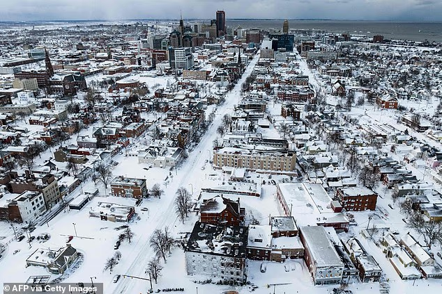
Snowy cities like Buffalo, New York (Pictured) are expected to have a lower than normal chance of a white Christmas this year due to the weather phenomenon El Nino
The new forecast, shared by Newsweek using data from the National Weather Service, has had to account for an El Niño that is causing colder and wetter conditions from California to the US Southeast.
Meanwhile, a pocket of dry air is expected to sit over the Midwest, bringing cold but less snowy weather to Ohio, Indiana, Illinois, Kentucky, Tennessee, Missouri and Arkansas.
A strong El Niño also brings warmer air to the Pacific Northwest, Northern Plains and Great Lakes, meaning states that typically see lake effect snow earlier in the winter season will now see a more complicated holiday forecast take shape.
As for the Northeast and New England, early season forecasts project that there will be more storms with mixed precipitation, potentially washing away the chances of a snowy Christmas in areas like New York, Boston and Philadelphia.
AccuWeather meteorologist Peyton Simmers told Newsweek: ‘December during traditional El Niños is typically warmer than the historical average, yielding a lower-than-historical-average chance for a white Christmas across the eastern United States.’
Long-range climate forecasters have previously predicted that the Northeast could see snow totals throughout the entire winter which are significantly below average.
During the Super El Niño, the National Oceanic and Atmospheric Administration (NOAA) has said that several northeastern states, including New York, Vermont and Pennsylvania, could see average snow totals drop by up to ten inches because of the unseasonably warm weather expected.
Similar drops are expected throughout New England, Michigan, Wisconsin and Iowa.

The last major snow event in Las Vegas, Nevada came in 2008 (Pictured)
For those hoping for a white Christmas, the best bets might be in a very unusual place – the American Southwest.
NOAA has predicted that northern and western California, southern Nevada and central Arizona are all expected to see several more inches of snow than they normally receive each year.
El Niño forms when the surface temperature of the Pacific Ocean becomes noticeably warmer than its historical average. A Super El Niño means those temperatures rise by more than 3.6 degrees Fahrenheit (2.0 degrees Celsius).
AccuWeather meteorologists have predicted that this year’s El Niño will likely be the strongest in recorded history, with sea-surface temperatures in the Pacific rising by 4.8°F (2.66°C).
Stronger El Niños mean even more intense winters in these areas, including snow totals that can rise two to ten inches above each state’s yearly average.
The Farmers’ Almanac, which has been making its time-honored winter forecasts since 1818, was slightly more optimistic about the prospect of a white Christmas this year.
Their winter outlook called for more periods of snow throughout the Northeast, Midwest and Northern Plains between December and March. However, their forecast suggested that the storms could easily turn to rain or sleet with little warning.
‘Winter 2026-2027 may be defined by contrasts: an active and wet southern storm track, quick bursts of snow and cold across the North and a particularly unpredictable mix of precipitation in the Northeast,’ the publication declared.
‘Keep the snow shovel, rain boots and ice scraper close at hand. This winter, you may need all three.’