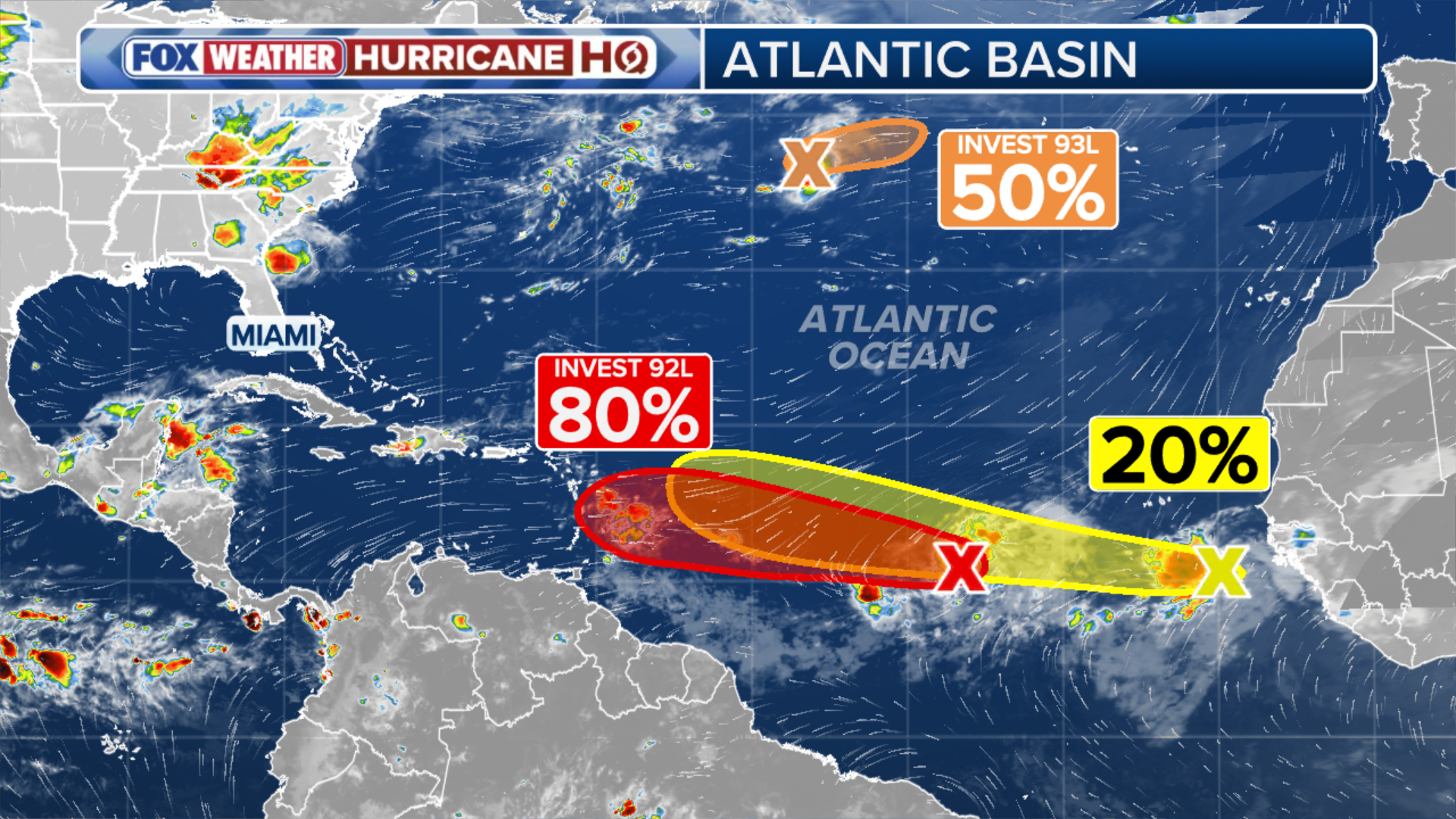
Invest 92L is eyeing a likely upgrade to a tropical depression by the weekend as activity ramps up across the Atlantic. FOX Weather meteorologists Britta Merwin and Craig Herrera break down all three areas currently to watch in the basin:
The National Hurricane Center (NHC) is monitoring three areas in the Atlantic for potential tropical development in what has been a quiet start to the 2026 hurricane season, particularly across the Atlantic’s Main Development Region (MDR) — the area between Africa and the Caribbean where many hurricanes begin to form.
WHAT IS AN INVEST DURING HURRICANE SEASON?
The NHC designated the main disturbance in the Atlantic as Invest 92L on Tuesday, with the FOX Forecast Center highlighting it as the primary focus of concern, carrying a high chance of development over the next week.
(FOX Weather)
Trailing right behind 92L is a tropical wave rolling off the coast of West Africa with a low chance of development.
Elsewhere in the basin, Invest 93L has now been designated, with a medium chance of development.
LATEST FROM FOX WEATHER HURRICANE SPECIALIST BRYAN NORCROSS
The term “invest” is used every hurricane season in the Atlantic and the Eastern and Central Pacific basins, accompanied by a number from 90 to 99 and either the suffix “L,” “E” or “C,” respectively.
As all eyes are on the MDR, where Invest 92L is leading the charge across the tropical Atlantic, the NHC has given it high odds of developing into at least a tropical depression within a couple of days.

(FOX Weather)
The system is about a third of the way from Africa to the Caribbean and will track in the general direction of the northeast Caribbean for the next few days.
WHAT’S THE DIFFERENCE BETWEEN A TROPICAL DEPRESSION, TROPICAL STORM AND A HURRICANE?
“The NHC’s development zone is long because it’s uncertain where and when the window of development opportunity might open,” the FOX Forecast Center said.
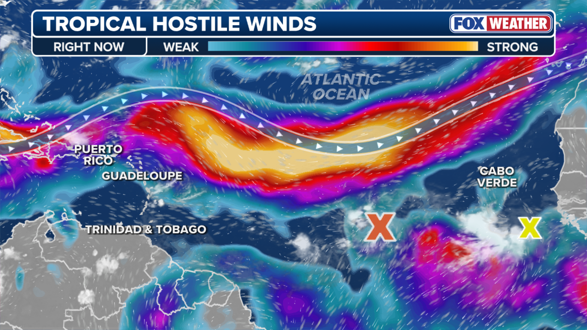
To capitalize on that window, 92L must consolidate more moisture while overcoming dry Saharan dust along its path.
As it gets near the islands, hostile upper-level winds will become an issue. These negative factors should keep the system from becoming very strong.
INVEST 93C CHURNS IN THE PACIFIC AS STORM COULD BECOME A TROPICAL DEPRESSION BY WEDNESDAY
However, it still has a slight chance of developing into a low-end tropical storm. The name would be Cristobal if it develops.
(FOX Weather)
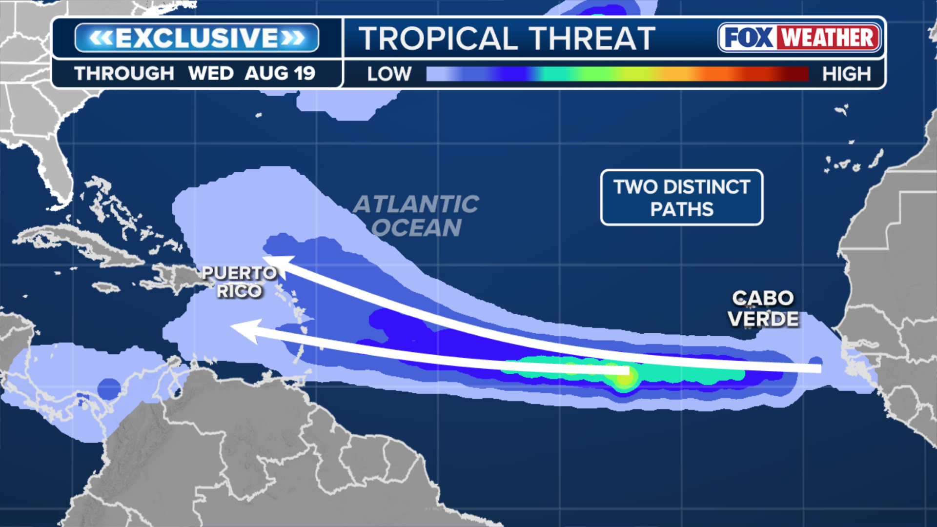
According to the FOX Forecast Center, “computer forecast models are divergent on whether the system can fight off the dust and upper winds long enough to strengthen much at all. In fact, the AI models don’t focus on the NHC’s system but instead give the one behind it a better chance to come together.”
The system trailing Invest 92L is a wildcard that has captured the attention of the National Hurricane Center.
Highlighted as an area to watch, this tropical wave sits just offshore of West Africa, producing disorganized showers and thunderstorms.
Right now, it has a low potential of development over the next seven days, but the FOX Forecast Center notes that it’s worth watching, with two scenarios at play.
(FOX Weather)
The first scenario is that Invest 92L acts as a lead blocker. By taking the brunt of the hostile wind shear and Saharan dust, it could essentially clear a cleaner, more favorable path for the trailing wave to develop.
If this were to happen, there could be a shift in the development percentages for Invest 92L, but things are still very uncertain.
The other scenario, which seems more likely, is that Invest 92L forms into a depression or storm in the general vicinity of the northeastern Caribbean islands sometime around Sunday.
If the general atmospheric hostility wins out, and the system stays fairly weak, which looks most likely at the moment, chances favor it tracking into the northeast Caribbean and bringing beneficial rain to Puerto Rico and the surrounding islands.
However, if it finds a bubble of atmosphere conducive for development, a stronger system is more likely to turn north into the open Atlantic before it reaches the islands.

Windy day at the beach.
(BlueFolio / Getty Images)
In contrast to the wildcard scenarios, the basin’s other designated system poses no threat to land.
Invest 93L is spinning in the subtropical Atlantic well northeast of Bermuda, where it carries a medium chance of development.
The National Hurricane Center tagged the system after satellite imagery showed an area of low-level spin, but its development window is closing as it tracks into cooler water temperatures.