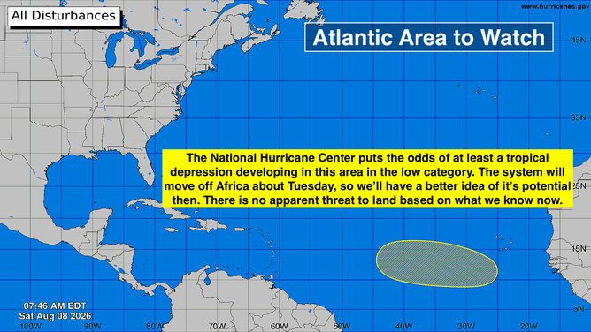
A new area to watch for tropical development has been declared in the Atlantic. It has low chances for development over the next week. Joining to provide exclusive analysis on the area to watch is FOX Weather Hurricane Specialist Bryan Norcross.
Updated at 10 a.m. on Saturday, Aug. 8, 2026.
The National Hurricane Center is painting a large yellow area to watch in the central tropical Atlantic. Notice there is no X designating the center of the system in question. That’s because that disturbance is still over Africa. It’s forecast to move off the coast about Tuesday.
Long-range computer forecast models give the system a decent chance of developing into at least a tropical depression in that area late in the week, but the NHC is keeping the odds in the low category for now.
Overview of area to watch in Atlantic on Aug. 8, 2026.
(Bryan Norcross / FOX Weather)
The Saharan dust and hostile upper-level winds we’ve been talking about continue to dominate the tropical belt from the Caribbean to Africa, but this disturbance is far enough south that it has a little runway to develop. In addition, a weak system right in front of it might moisten a corridor west before the bigger system moves over the Atlantic on Tuesday.
For the most part, long-range projections show the system, whether it develops or not, eventually turning north into the Atlantic. Forecasts for any system that has not even begun to organize are always iffy, however, so don’t pay much attention to long-range tracks for an undeveloped system.
This is all happening more or less on schedule. The Atlantic is warming up and the African disturbances are becoming more robust. It doesn’t change the fact that the overall weather pattern across the tropics is generally hostile to development, however. The unsupportive conditions should, as a rule, make development less likely and limit the strength of storms this year. But named storms and hurricanes are still going to form.
In the Pacific
The National Hurricane Center is watching three areas for potential development. The one of most concern is the orange area, which indicates Disturbance #1’s chance of development into at least a tropical depression is now in the medium range. This is the same potential system that we’ve been discussing for the last several days.
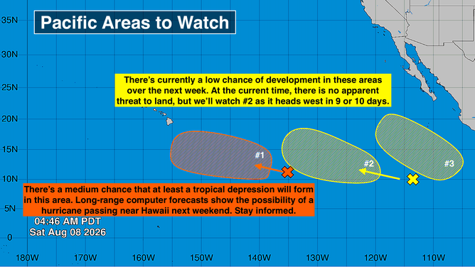
A very active Central and Eastern Pacific on Aug. 8, 2026.
(Bryan Norcross / FOX Weather)
The consensus of the long-range computer forecast models is that a tropical system will indeed develop in that orange area and intensify into a tropical storm or hurricane as it tracks in the general direction of the Hawaiian Islands. On the current schedule, it would be near Hawaii next weekend.
The odds currently favor a track south of the islands, but forecasts for systems that have not yet developed are always subject to adjustment and potentially significant change.
Since the system is coming from the southeast, it will be over warm water. That gives it the potential to maintain more strength than systems we’ve seen tracking near the islands, but arriving from the east over cooler ocean waters.
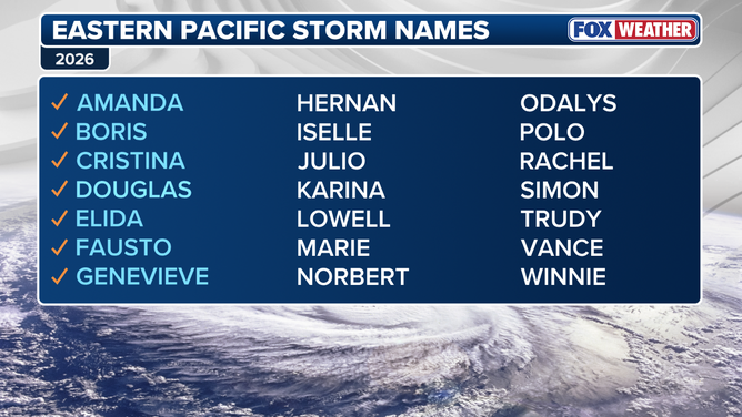
East Pacific hurricane names 2026
Maintain vigilance in Hawaii this week. Let’s see how the system comes together over the next few days. After that, we should have more confidence in the forecast.
Neither of the other two disturbances with low chances to develop in the yellow-painted areas looks like a threat to land. Although we’ll keep an eye on system #2. If it does develop, it will want to head west in the general direction of Hawaii, but that’s a long way off, and there is little evidence of that at the current time.