Colorado State University said the odds of a major Atlantic hurricane making landfall in the continental United States remain “well below-average” as researchers are “extremely confident” a strong El Niño will be present during the peak of the season. FOX Weather Hurricane Specialist Bryan Norcross explains:
Colorado State University (CSU) maintained its Atlantic hurricane season forecast Wednesday, saying the odds of a major hurricane making landfall in the continental United States remain “well below-average” as researchers are “extremely confident” a strong El Niño will be present during the peak of the season.
CSU pioneered seasonal Atlantic hurricane forecasts beginning in 1984.
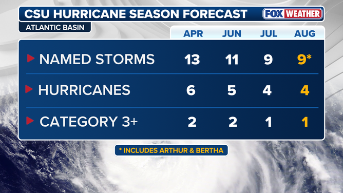
The August CSU forecast remains unchanged from July’s, calling for 9 named storms, 4 hurricanes, including 1 major (Category 3 or stronger) hurricane this year — down from its June forecast of 11 named storms, 5 hurricanes and 2 major storms.
August Colorado State University Atlantic hurricane season forecast
(FOX Weather / FOX Weather)
In comparison, an average Atlantic hurricane season produces 14 named storms, including 7 hurricanes and 3 major hurricanes.
WHAT’S THE DIFFERENCE BETWEEN A TROPICAL DEPRESSION, TROPICAL STORM AND HURRICANE?
The latest CSU forecast remains in line with NOAA’s seasonal forecast and includes Tropical Storms Arthur and Bertha, which made landfall along the Gulf Coast as weak tropical storms — the only tropical activity in the Atlantic basin thus far this season.
Tropical Storm Arthur made landfall on June 17 and brought flooding rain along the Upper Texas Coast, including in Matagorda and Brazoria counties.
Meanwhile, Tropical Storm Bertha skirted the northern Gulf Coast, bringing gusty winds and rough surf to the Florida Panhandle, Alabama and Mississippi, before making an initial landfall in St. Bernard Parish, Louisiana, on July 22.
TROPICAL STORM BERTHA WASHES AWAY FLORIDA SEA TURTLE NESTS
Bertha briefly reformed over the northern Gulf before quickly moving into the Upper Texas Coast, bringing a shot of rain to the region.
BERTHA BATTERS COAST 🌀: FOX Weather Correspondent Brandy Campbell reports amid gusty winds in Biloxi, Mississippi, where the effects of Tropical Storm Bertha are battering the coast, threatening residents with severe flooding.
CSU said it expects El Niño to continue to strengthen and dominate tropical weather patterns during the peak of the season from mid-August to mid-October.
El Niño is typically associated with fewer hurricanes in the Atlantic.
It is one of three phases of a climate cycle called the El Niño-Southern Oscillation (ENSO). It describes natural temperature changes in the central Pacific Ocean that alter atmospheric circulation and can greatly influence global weather.
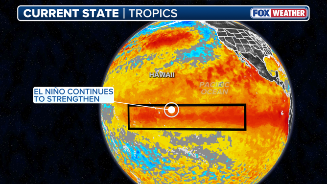
This graphic shows the El Niño zone.
(FOX Weather)
El Niño describes warmer than average water across the equatorial Pacific, while La Niña describes colder than average water conditions, and ENSO neutral refers to a state where temperatures are close to average.
During El Niño, above-average water temperatures in the central and eastern Pacific Ocean alter the position and strength of the subtropical jet stream. It’s typically more robust and extends well into the Caribbean and Atlantic Ocean. The jet stream is a belt of very fast winds high in the atmosphere.
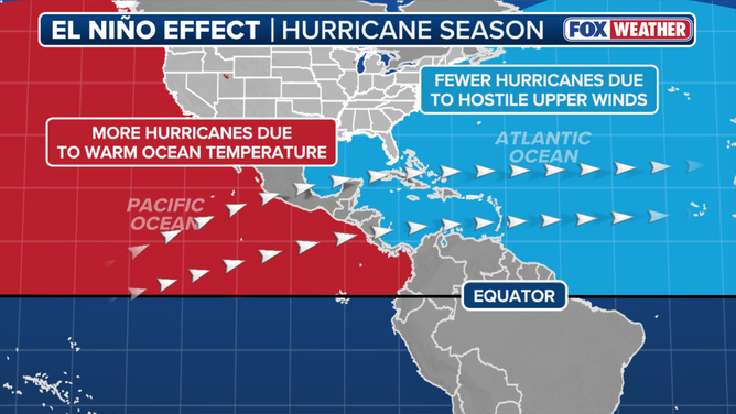
El Niño impact on hurricane season.
(FOX Weather / FOX Weather)
It’s these strong winds that hinder tropical development in the Atlantic during an El Niño. Calm conditions are generally more conducive to hurricane formation.
EL NIÑO SURGES TOWARD ‘MONSTER’ TERRITORY, SIGNALING AN ACTIVE WINTER FOR EAST AND WEST COASTS
When water temperatures in the El Niño zone reach at least 2 degrees Celsius above average for at least three consecutive months, it is considered a Super El Niño. These events are not as common as a typical El Niño and have a massive influence not only on the Atlantic hurricane season, but also other weather patterns around the globe.
Taken in a vacuum, the stronger the El Niño event, the more wind will be present to limit storm development in the Atlantic.
Much of the Atlantic basin continues to remain quiet as a dense Saharan dust cloud dominates the tropics. However, out in the far eastern waters, a large disturbance sits west of the Cabo Verde Islands. FOX Weather Hurricane Specialist Bryan Norcross gives us his exclusive analysis:
CSU states a moderate-to-strong El Niño conditions are already present and is very likely to reach a strong El Niño (greater than 1.5°C) by the peak of the season.
However, many other factors outside of El Niño can impact Atlantic hurricane activity, most notably water temperatures in the tropical Atlantic.
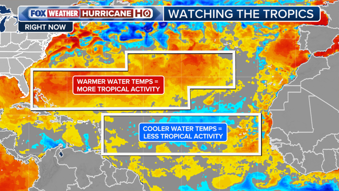
Atlantic sea surface temperatures.
(FOX Weather / FOX Weather)
Generally, water temperatures need to be above 80 degrees Fahrenheit to sustain tropical development.
Right now, the tropical Atlantic is close to average or just below average for this time of the year, meaning the basin is not getting the extra boost from warmer waters compared to previous seasons.
HERE’S HOW EL NIÑO AFFECTS THE FUTURE OF CORAL REEFS
According to CSU, the probability of a major hurricane making landfall anywhere along the U.S. coastline this year has dropped to 16%, down from 24% in June and well below the historical average of 43% from 1880 to 2020.
Meanwhile, El Niño events typically enhance development in the Eastern Pacific due to the warm water temperatures.
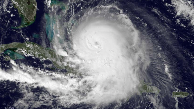
NOAA satellite imagery of Hurricane Joaquin on October 1, 2015, which reached Category 4 status during a Super El Niño year.
(NOAA)
Beyond these projections, both CSU forecasters and FOX Weather Hurricane Specialist Bryan Norcross cautioned that even in seasons with fewer storms, it only takes one to create major impacts.