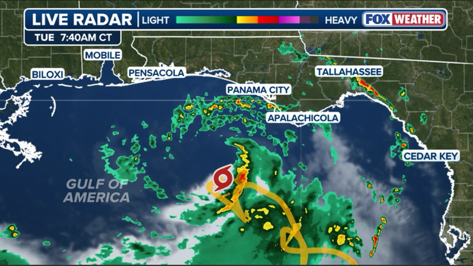
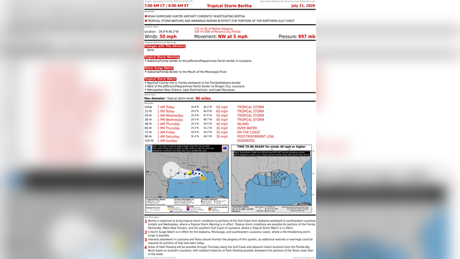
Additional watches and warnings have been issued Tuesday as Tropical Storm Bertha struggles to organize, but it is still on track to bring significant weather to the coast. Rounds of downpours will pinwheel in off the Gulf, accompanied by gusty winds up to 50 mph. FOX Weather Hurricane Specialist Bryan Norcross breaks down the latest analysis:
Updated at 10:15 a.m. on Tuesday, July 21, 2026.
Tropical Storm Bertha is producing some winds gusting near hurricane force, but they are confined to a robust thunderstorm cell near the center of rotation well offshore of the Florida Panhandle.
Dry air has penetrated the circulation since the get-go and continues to be an inhibiting factor. In addition, the upper-level winds over the Gulf are hostile to dramatic development.
TRACK TROPICAL STORM BERTHA: LIVE RADAR, FORECAST CONE, FLOOD THREAT, WIND SPEED AND WARNINGS
Tuesday morning radar of Tropical Storm Bertha
(FOX Weather)
Bertha might intensify a bit more, but the strong upper winds are forecast to increase as it tracks in the direction of southeastern Louisiana, so the intensity is likely to peak soon, and the strongest winds will stay offshore. The National Hurricane Center’s forecast shows slow weakening beginning tomorrow.
Some outer bands containing gusty tropical downpours are arcing over the coast and adjacent inland areas. There is some potential for flash flooding in isolated spots. But most of the heavy rain will remain offshore.
TROPICAL STORM BERTHA STRENGTHENS, THREATENS GULF COAST WITH HEAVY RAIN, STORM SURGE AND SQUALLS
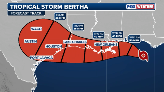
Tropical Storm Bertha forecast cone
(FOX Weather)
Bertha’s main effect will be at the coast. The persistent and strong winds on the backside of the circulation will push Gulf water above the normal tide levels. A water rise of 2 to 4 feet above normal high tide is possible, especially in the low-lying areas of southern Alabama, Mississippi, and southeastern Louisiana.
In addition, the surf will be dangerous with large waves and rip currents likely. Pay attention to alerts.
TIMELINE: WHEN YOU WILL SEE FIRST IMPACTS OF TROPICAL STORM BERTHA IN THE SOUTHEAST
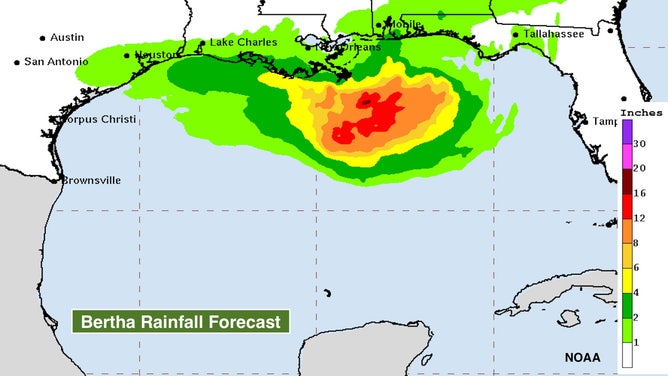
Tropical Storm Bertha’s rain forecast
(NOAA)
There’s high confidence that Bertha’s center will track west offshore of the western Florida Panhandle and Alabama. As the system nears Mississippi and Alabama late on Wednesday, the forecast is less certain.
The most reliable computer forecasts – both the consensus of traditional models and the Google DeepMind model – indicate that the increasing upper winds could rip the system apart, disconnecting the upper circulation from the one we track at ground level. In that case, the system would die out over or near southern Louisiana. But that’s not 100%.
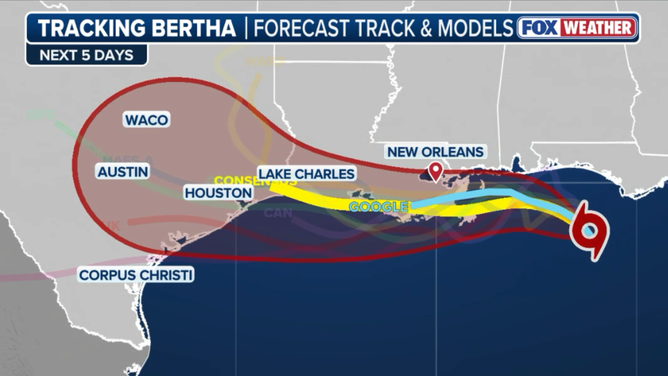
Different forecast models for Tropical Storm Bertha.
(FOX Weather)
Whether it’s a weaker system or just a remnant, tropical moisture with some gusty winds could continue west toward Texas. There is no indication of a strong storm impacting the Texas coast, however.
Poorly developed systems over the very warm Gulf water can surprise us, so everyone along the Gulf Coast from the Florida Panhandle to Texas should stay aware.
Tropical Storm Bertha
(Bryan Norcross / FOX Weather)
Track errors for weak systems are, on average, three times as large as they are for strong hurricanes. When a system is moving slowly like this, it compounds the uncertainty. So stay informed, just in case.