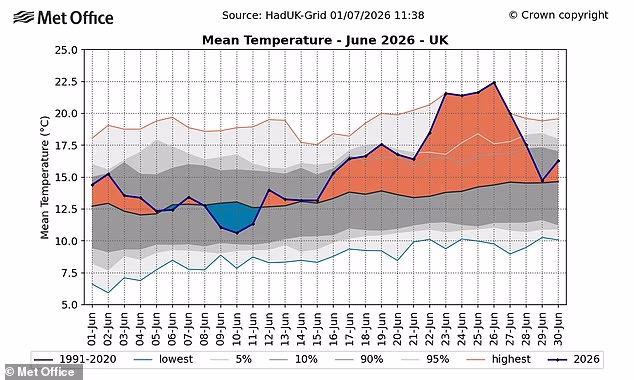
England has sweltered through the hottest June ever, official figures show.
Provisional figures reveal that across the country, the average temperature was 17.1°C last month, surpassing the previous record of 16.9°C set in 2025.
The exceptional warmth was driven by an intense and record-breaking heatwave at the end of the month, the Met Office said.
It was also bolstered by a slew of ‘tropical nights’, when the temperature did not drop below 20°C.
For the UK, June 2026 provisionally ranks as the second warmest June on record, behind only June 2023.
Wales recorded its second warmest, while Scotland and Northern Ireland both saw their joint fourth warmest June since 1884.
Professor Stephen Belcher, Met Office Chief Scientist, said: ‘To see temperatures like this in the UK in June is sobering.
‘Events like this bring home the implications of climate change, with very high temperatures and humidity bringing significant health implications from heat stress, as well as impacts to a range of sectors such as transport, energy and water supply.’
The exceptional warmth was driven by an intense and record-breaking heatwave at the end of the month, the Met Office said

England recorded its warmest June on record, with a mean temperature of 17.1°C, surpassing the previous record set in 2025 and standing nearly 3°C above the long-term average
Experts said that while June started off with generally cloudy, unsettled conditions, this shifted about halfway through the month.
The second two weeks are likely to be remembered for the exceptionally hot and humid heatwave that delivered record-breaking June temperatures and unprecedented overnight warmth in many areas.
This was the first time that a Red Warning for Extreme Heat was issued for three consecutive days in the UK.
June’s temperature record was broken several times – with the hottest recording of 37.7°C being registered at Lingwood in Norfolk last Friday.
‘This June is a clear example of how UK weather can deliver both unsettled conditions and record-breaking heat within the same month,’ Met Office Scientist Dr Emily Carlisle said.
‘The intensity of the late June heatwave, combined with exceptionally warm nights, has driven England’s warmest June on record for mean temperature, while the UK and Wales recorded their second warmest June on record.
‘Coming 50 years after the 1976 heatwave, it also highlights how similar events are now playing out in a warmer climate, with higher temperatures and more widespread impacts than we would have seen in the past.’
Met Office projections indicate that hot spells will become more frequent in our future climate, particularly over the south-east of the UK. Temperatures are expected to rise in all seasons, but the heat would be most intense in summer.

The UK, England and Wales all recorded their highest average minimum temperature for June since records began in 1884, each surpassing the previous record by around 0.5°C

People take a break and sit on deckchairs in the sun in Paternoster Square during the recent hot sunny weather on June 29

People flocked to pools and beaches in a bid to escape the heat. Pictured: People swimming at London Fields Lido last month
Experts recently warned that a ‘super El Niño’ could bring even hotter conditions to the UK later this summer.
NASA satellites have confirmed that the weather phenomenon – characterised by warmer water in the equatorial Pacific – is ‘underway’.
The space agency predicts this El Niño event will have ‘widespread effects’, including bringing wetter conditions to the American Southwest and drought to countries in the western Pacific.
But experts say we can also expect extreme heat ‘almost everywhere’ – including the UK.
While its influence on British weather is indirect, a particularly strong El Niño event could raise global temperatures and supercharge the heating effects of climate change.
Simon Culling, a prominent data collector and investigator for the UK’s Tornado & Storm Research Organisation (TORRO), wrote on X: ‘If the current predictions for the forthcoming El Niño phase are realised, what does this mean for the UK?
‘It may mean hotter summers for both 2026 and 2027 and increases the risk of a significant cold spell in winter 2026/27. Let’s see what plays out.’
While its effects on the UK are yet to be determined, meteorologists say El Niño’s intensity will likely be comparable to the 1997/98 event which saw global temperatures reach their highest on record.

The WMO has warned that people should prepare for hotter-than-normal temperatures ‘across nearly all parts of the globe’
During its development, the UK experienced an exceptionally hot, sunny and humid August characterised by heatwaves.
Speaking on the possible development of El Niño, Grahame Madge, a climate science communicator at Met Office, previously said: ‘This is likely to be a significant event.
‘It’s likely to be the strongest El Niño event so far this century. And we’re probably comparing it to the 1998 one. This was a significant year for global temperature and at the time, it was the warmest year on record.’
Mr Madge said that while the influence of El Niño is a significant driver in global weather, it’s not the only one.


