A massive heat dome is expected to dominate the weather across the eastern U.S., and its life-threatening heat is only part of the story. FOX Weather Meteorologist Steve Bender breaks down what to expect as dangerous conditions persist and thunderstorms ignite around the sprawling dome of oppressive heat.
Updated at 9:15 a.m. ET on Wednesday, July 1, 2026.
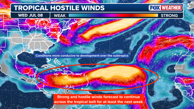
The deep tropics from the Caribbean across the Atlantic to Africa are about as hostile to tropical development as you’re ever going to see during a hurricane season. There’s a fire hose of upper-level winds from Central America almost to Africa. This on its own would normally prohibit tropical systems from developing.
DEEP TROPICAL MOISTURE BRINGS FLOOD THREAT TO FLORIDA DESPITE 0% CHANCE OF TROPICAL DEVELOPMENT
In addition, the Atlantic east of the islands is unusually cool, too cool to power tropical systems. And the Saharan dust machine is kicking in. Winds over the African continent are kicking up the dust, which is carried across the Atlantic to the Caribbean, and sometimes to Florida and the Gulf.
A dense plume has been over Puerto Rico and the Virgin Islands, which is now dispersing farther west.
This graphic shows that strong and hostile winds are forecast to continue across the tropical belt for at least the next week.
(Bryan Norcross / FOX Weather / FOX Weather)
The net result is that no tropical development is expected for the next week, and the long-range computer forecast models show nothing developing into the middle of the month.
Is the belt of hostile upper-level winds an artifact of this year’s much-ballyhooed developing El Niño? It’s a bit of an open question — usually it takes longer for the atmosphere to respond to the warming pool of water south of Hawaii in the Pacific. In any case, Mother Nature has a lid on the tropical Atlantic.
BRYAN NORCROSS: KEEPING A HALF AN EYE ON AN AREA OF LOW PRESSURE OFF THE SOUTHEAST COAST
If anything is going to develop anytime soon, it’s going to be north of the tropical belt. The northern Gulf and the waters off the Southeast coast and east of North Florida — the so-called subtropics — don’t have as many negative factors in play. So for the foreseeable future, we’ll continue to watch for disturbances in those areas.

This graphic shows that tropical development is not expected for at least the next seven days.
(Bryan Norcross / FOX Weather / FOX Weather)
On average, the Saharan dust lets up and the tropical oceans warm in August. There’s no reason to think that won’t happen this year as well.
But for now, Mother Nature is taking an extended July 4th holiday.


