Sunday, June 28, 2026
No Result
View All Result
LJ News Opinions
  • Home
  • U.S.
  • Politics
  • World News
  • Business
  • Entertainment
  • Sports
  • Technology
  • Health
  • Opinions
  • Home
  • U.S.
  • Politics
  • World News
  • Business
  • Entertainment
  • Sports
  • Technology
  • Health
  • Opinions
No Result
View All Result
LJ News Opinions
No Result
View All Result
Home Opinions

Bryan Norcross: Slight chance of tropical development off the Southeast

by LJ News Opinions
June 28, 2026
in Opinions
0
Share on FacebookShare on Twitter


The National Hurricane Center has designated a new area to watch for tropical activity off the coast of the Southeastern U.S. FOX Weather Hurricane Specialist Bryan Norcross gives his expert analysis on what this new area to watch could look like as we head into the holiday week.

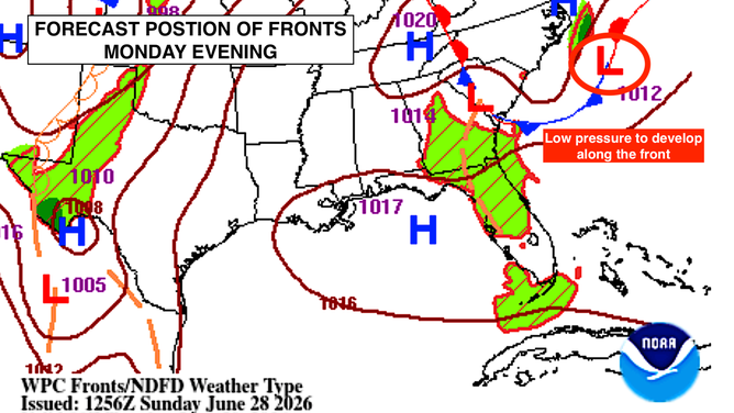
The frontal system that has been causing all the rain in the Midwest and the mid-Atlantic is forecast to sink south and offshore of the East Coast. By Monday evening, a weak area of low pressure is expected to develop along the front. This is a typical development that occurs off the Southeast coast, at least partially energized by the warm water of the Gulf Stream.

SEVERE STORM THREAT SHIFTS EAST AFTER DEADLY, CATASTROPHIC FLOODING SLAMS KENTUCKY AND INDIANA

Around Wednesday, that low-pressure system could break free of the front and acquire some tropical characteristics over the warm ocean water. The circulation, if it develops, is expected to be broad, and there’s unlikely to be enough time for it to spin up into anything significant before it dissipates or perhaps moves over land late in the week.

A look at the frontal system.

(Bryan Norcross / NOAA)

The odds of anything tropical developing look to be lower today based on multiple computer forecast models. But a few, continue to show a slight chance of development. The National Hurricane Center is still carrying 20% odds that the system becomes at least a tropical depression.

AREA TO WATCH DESIGNATED OFF SOUTHEAST COAST, BRINGING POTENTIAL TROPICAL TROUBLE HEADING INTO JULY 4

The air mass associated with the heat-dome high-pressure system over the eastern U.S. will be very dry, which should be an inhibiting factor to any significant tropical development.

New area to watch designated in the Atlantic.

(Bryan Norcross / FOX Weather)

Even in the unlikely event that a tropical depression forms, it now looks unlikely that it would affect land in any disruptive way.

HOW TO WATCH FOX WEATHER

We’ll keep an eye on it, but there’s no reason to stare very hard.


Source link

Tags: forecastGeorgiahurricanesNorth CarolinaoceanSouth CarolinasoutheastStay22US
LJ News Opinions

LJ News Opinions

Next Post
Simon Peter Carman, a man with short light brown hair wearing a sleeveless black too, is escorted by a Thai police officer.

Australian man charged with murder after girl found dead in suitcase in Thailand

Recommended

The real Frankenstein’s lab: Controversial start-up is using disembodied human BRAINS for drug testing

1 month ago

VIDEO: US Coast Guard boat smacked by Hurricane Erin’s waves

10 months ago

Popular News

    Connect with us

    LJ News Opinions

    Welcome to LJ News Opinions, where breaking news stories have captivated us for over 20 years.
    Join us in this journey of sharing points of view about the news – read, react, engage, and unleash your opinion!

    Category

    • Business
    • Entertainment
    • Health
    • Opinions
    • Politics
    • Sports
    • Technology
    • U.S.
    • World News

    Site links

    • Home
    • About us
    • Contact

    Legal Pages

    • Privacy Policy
    • Cookie Privacy Policy
    • Terms of Use
    • Disclaimer
    • California Consumer Privacy Act (CCPA)
    • DMCA
    • About us
    • Advertise
    • Contact

    © 2024, All rights reserved.

    No Result
    View All Result
    • Home
    • U.S.
    • Politics
    • World News
    • Business
    • Entertainment
    • Sports
    • Technology
    • Health
    • Opinions

    © 2024, All rights reserved.