A Tropical Storm Watch has been issued for millions along the Gulf of America, as life-threatening conditions could strike in the next 48 hours.
The National Hurricane Center (NHC) on Tuesday designated the system as Potential Tropical Cyclone One, marking a significant escalation in the threat as it moves toward the Gulf Coast.
Forecasters said there is a 60 percent chance the disturbance will strengthen into a tropical depression or tropical storm by Wednesday.
A tropical depression is a weaker, less organized system with maximum sustained winds of 38mph or less, and a tropical storm is defined as a more organized and intense system with sustained winds between 39 and 73mph.
If the system reaches tropical storm strength, it would become the first named storm of the 2026 Atlantic hurricane season to threaten the US Gulf Coast.
The watch is in effect from Sargent, Texas, to Morgan City, Louisiana, where residents are being urged to prepare for major flooding, possible evacuations and water rescues.
The system could dump four to eight inches of rain across parts of Texas, Louisiana, Mississippi, Alabama and the western Florida Panhandle through Thursday, with isolated totals reaching 12 inches.
Forecasters warned the resulting flash flooding could become life-threatening in some areas, while a tornado or two is also possible from the upper Texas coast into Louisiana, Mississippi, Alabama and the Florida Panhandle.
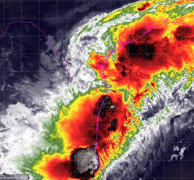
If the weather front reaches tropical storm strength, it would become Arthur, the first named storm of the 2026 Atlantic hurricane season. Above, a satellite image of the system in the Gulf
AccuWeather meteorologists said in a statement: ‘The potential for life-threatening flooding should have the attention of tens of millions near the Gulf Coast and across the Southeast US as heavy rain will continue throughout the week, enhanced by what could be the first tropical storm of the year.’
The weather system currently has a wind force of up to 30mph.
The National Weather Service (NWS) the storm is not expected to produce sustained tropical-storm-force winds, with speeds likely remaining below 39 mph.
While the threat to life and property from wind remains low at this time, residents could still experience gusty conditions and are being urged to stay prepared should the forecast change.
‘Strongly consider protective actions, especially if you are in an area vulnerable to flooding,’ the NWS stated.
‘Heed any flood watches and warnings. Failure to take action will likely result in serious injury or loss of life.’
AccuWeather forecasts eight to 12 inches of rain to fall around Houston and an area stretching from the eastern Texas coastline, across Louisiana and into central Mississippi.
New Orleans is on the edge of the heaviest rain but can still experience torrential rain rates of two to four inches per hour, which can quickly lead to life-threatening flooding.
AccuWeather vice president of forecasting operations, Dan DePodwin, said in a statement: ‘The additional downpours from the tropical rainstorm will pose a serious risk for major flooding that could quickly turn life-threatening.’
This is a developing story… More updates to come.


