RETURNING STORMS: A round of severe storms is returning to the Great Plains and the Midwestern U.S. this weekend, with forecasters eyeing the threat of large hail, damaging winds, and possibly tornadoes.
As the stagnant Omega block weather pattern wanes, the chance for new severe storm development is taking shape across the Great Plains and midwestern U.S. through the weekend.
After days of heat across the Central U.S., the high pressure system caught in the middle will now start to flatten, allowing a series of storm systems to pour into the Plains.
WHAT IS A SUPERCELL THUNDERSTORM?
This comes as regions such as central Kansas, including Wichita, are under a Level 2 out of 5 risk of severe thunderstorms, according to the National Oceanic and Atmospheric Administration (NOAA).
(FOX Weather)
Thursday to Saturday: Severe storm setup
Forecasters are expecting a mid-level wave to push eastward, along with a developing dryline that could allow severe storms to form.
According to the FOX Forecast Center, all the atmospheric parameters needed for storm development will be available.
HOW HIGH PRESSURE AND LOW PRESSURE DRIVE THE WEATHER
Still, a stout cap may shut down the odds of this severe setup.
A stout cap is a layer of relatively warm air hovering several thousand feet above the ground, which suppresses or delays the development of thunderstorms, according to NOAA.
⛈️ MASSIVE HAIL: Hail came splashing down into the pool outside of a residence in Scurry County, Texas, where locals are under a severe thunderstorm watch for the rest of the day.
If these storms develop, they could produce hail up to 2 inches, and the severe pattern could continue through Saturday, when a more robust area of low pressure will develop, allowing more moisture to fuel storms in the North.
Sunday to Monday: Storm threat
Starting Sunday, the continuous atmospheric setup is expected to become more likely to change as an upper-level trough hovers over the western U.S., bringing strong southwesterly flow over the Great Plains.
SOUTHERN CALIFORNIA BEACHGOERS FACE FOUL SMELL AS UNTREATED WASTEWATER POLLUTES POPULAR WATERS
Due to this flow of development, a significant surge of low-level moisture with a surface dew point in the mid to upper 60s is expected across most of the North-Central U.S.
This upper-level energy will enhance the storm threat.
(FOX Weather)
“A series of subtle shortwave troughs moving through this environment will likely trigger scattered to numerous thunderstorms during the afternoon and evening hours,” the FOX Forecast Center said.
WHAT IS A DRYLINE AND WHY IS ITS LOCATION IMPORTANT IN SEVERE WEATHER FORECASTING?
The greatest risk of severe storms will include supercells capable of producing large hail, damaging winds and possibly tornadoes.
This severe threat is mainly focused across eastern Nebraska and western Iowa.
Severe thunderstorm blasts Myrtle Beach, South Carolina, with strong wind gusts and hail Monday.
In fact, popular locations such as Des Moines, Iowa, and Minneapolis, Minnesota, are under a Level 1 out of 4 flash flood threat as the chance of heavy rain and thunderstorms will persist throughout the weekend.
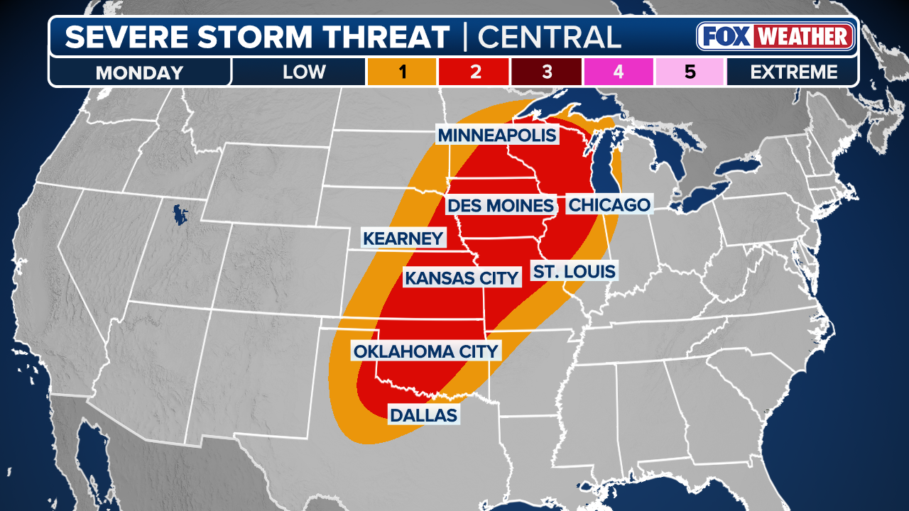
By Monday, this severe setup will continue, as a large Level 2 out of 5 severe storm threat is active across northern Wisconsin, stretching south into northern Texas.
It is possible that extreme moisture combined with wind shear could support further development of stronger storms, but expect more wet weather to start next week.


