HOUSTON — A Weather Impact Alert has been issued for late tonight into early Monday morning as a cold front could bring strong thunderstorms to parts of Southeast Texas while many people are asleep. The greatest severe weather threat will stay north of the Houston area, but there is still a chance some stronger storms could develop locally overnight.
Don’t worry — If you have Mother’s Day plans, weather conditions will be quiet, warm and muggy throughout most of the day with afternoon highs in the upper 80s. So, breakfast or brunch with Mom will not be impacted. Skies will be partly cloudy with winds out of the south at 5-10 mph. Storm chances will ramp up around midnight and last through the morning hours of Monday.
The main concern arrives tonight as a front moves into Southeast Texas after midnight. FutureTrack models show showers and thunderstorms beginning to develop Sunday evening before the stronger line approaches overnight. There is currently a layer of stable air in place that could help weaken some storms before they reach Houston. However, if that layer does not hold, stronger thunderstorms could move through the city while residents are sleeping.
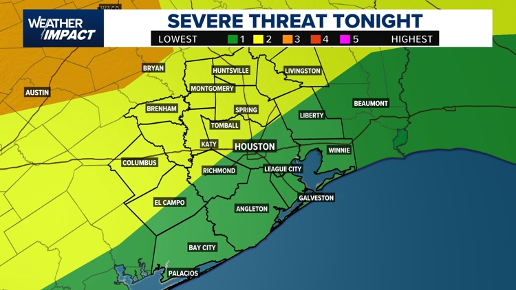
The Weather Impact Alert is in effect from 8 p.m. Sunday through about 5 a.m. Monday. Areas north of Houston face a Level 2 severe weather risk, while Harris County and Houston are under a Level 1 risk. The primary threats include gusty winds and isolated hail. By daybreak Monday, most of the storms are expected to move out, leaving behind a stretch of warmer, humid weather with little to no rain expected through much of next week.
Sunday (Mother’s Day): Cloudy skies early with gradual clearing through the morning and afternoon. Most daytime plans should stay dry and warm with highs near 87 degrees. Isolated showers are possible Sunday evening before a stronger line of storms approaches overnight.
Sunday Night into Monday Morning: Weather Impact Alert in effect from 8 p.m. Sunday through 5 a.m. Monday. Strong thunderstorms may develop as a front pushes into Southeast Texas after midnight. Gusty winds and isolated hail are the main concerns, especially north of Houston.
Monday: Storms should move out before sunrise for most areas. Warm and humid conditions continue through the day with improving weather expected.
Next week: Forecast models show a mainly dry pattern settling in across Southeast Texas. Temperatures stay warm and muggy, but rain chances remain low after Monday morning.
Harris County (including Houston, Pasadena, Baytown), Fort Bend County (Richmond, Sugar Land, Missouri City), Montgomery County (Conroe, The Woodlands), Brazoria County (Angleton, Pearland, Alvin, Lake Jackson), Galveston County (Galveston, League City, Texas City), Liberty County (Liberty, Cleveland, Dayton), Walker County (Huntsville, New Waverly), Waller County (Hempstead, Prairie View, Waller), Polk County (Livingston, Corrigan), Chambers County (Anahuac, Mont Belvieu, Winnie), Wharton County (Wharton, El Campo), Washington County (Brenham), Matagorda County (Bay City, Palacios), Grimes County (Anderson, Navasota), Austin County (Bellville, Sealy), Colorado County (Columbus, Eagle Lake, Weimar), Trinity County (Groveton, Trinity).


